Position Adjustment
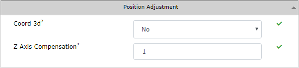
Coord 3d
possible values: Yes / No
default: No
Enables calculation in 3D using UWB signal. However, this approach is quite sensitive to Anchor’s placement and is currently not actively developed. Enabling may also cause errors in x, and y data. The Z-axis barometer option is preferred.
Z Axis Compensation
possible values: -1 (disabled) to 100 [m]
default: -1
This parameter can be used to further optimize the precision and performance of the system for 2D calculation, which is the most common scenario.
This parameter can help, when the height difference between Tags and Anchors is more than a few meters (>2m). The value should be set to the usual height of the Tag above the ground (e.g. if a person is wearing a tag around his neck on a strap, the height is approximately 1.5 m). The next step is to set the height coordinates of all Anchors- it is the height measured above the ground. Coordinates can be set via Sensmap -> tab RTLS -> section Nodes – [Anchor] Edit
Keep in mind that the Z Axis compensation is useful for applications where tags are approximately at the same height (± 0.5m).